Created 28-Jan-22
Modified 20-Dec-23
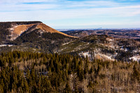
2022-01-22 | Deaths Head | 1741 max |1401 TH | 8.2km | 383 TA | w/ Shannon
On the list for a while but then off the list due to the normal summer route off Gorge Creek road being up through a clear-cut made in around 2020 or so. That route is long in the winter anyway due to closed traffic gates. This winter approach from the bridge that accesses well sites just north of the Mesa Butte rec area had a little route on the MapsMe app but little else, meaning the app had mined someone’s GPS track without any concern if it was a bad idea or not . That said it’s a more or less straight shot west and the route-finding was just finding the best zigs and zags through the trees and over a variety of slopes. Named on the 1895 map as “Deaths Head” presumably for its shape (from exactly what angle I’m not certain) – it was used as a camera station for mapping. Honestly – I think the only reason I wanted to summit was the name. And as luck would have it, we did find a head. (ooooo, a reason to read on!).
We started out in spikes on the packed and plowed service roads and then once on the trail of someone’s footprints through mostly thin loose snow we took them off as they were just gobbing in the warm weather. The tracks lead to someone’s tent but no further so loosely following the app route we headed off through the light trees and bush. This area was logged some time ago and is starting to regrow with some decent sized trees and alder. Along the way we saw many tracks of mostly deer and moose but occasionally wolf, in particular around the mostly intact carcass of a moose. My IG picture said we had been “keeping an eye out for moose” – the moose had it’s eye pecked out by a raven – and nobody got the reference. So disappointing. But I did make the photo black and white to eliminate the bloody overtone. At one point I spooked out what may have been a young moose but only got a fleeting glimpse. The last approach to the ridge was steep and slippery so we took our time. The west side of the ridge is the clear cut, so from snow and trees to a war zone rather abruptly. We took in the view and had lunch before returning the way we came except a more moderate drop off the ridge by traversing SE first. The snow here was knee deep but going mostly downhill it wasn’t too bad except for the occasional slap by an alder. A worthy outing for a so-so kinda January day. We need some snow to play in!
© Clayton Ditzler