Created 9-Jul-18
Modified 15-May-24
2018-07-07 | Association Peak, Association Hill | 2395m | 1355m TH | 25.7km | 2210m TA | w/ Peter & David
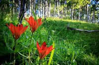
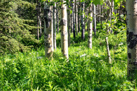
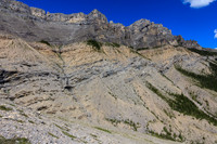
Big day, 13 hrs on the trail. First bit was up through a lovely bit of aspen forest punctuated with Wood lilies. Once on the Yamnuska shoulder we dropped along the Stoney Reservation border now on horse rototilled trail. Double edge to that as they clear the trail of downed trees, but in the wet bits it can be tedious going in the mud and slop. Across one creek, then Old Fort Creek we ascend again toward Association Peak. We ended up with maybe a touch more scrambling than necessary due to the route we chose, but it was never problematic. I found the rounded limestone scree to be particularly tiring due to its instability. The last bit of route up thru a cliff band had us on a broad ridge that connects to End mountain. We read the registers (one wet, one fragmented pages) and then descended out of the wind to gather water from a seep and have a bite to eat. Uneventful descent and a traverse to Association Hill - which for views I seemed to prefer (see pano) but it was also our first real warm boots off kind of summit of the season, so perhaps that affected my perspective. The route out was retracing our steps through the slop etc. I found the last push up the Yam shoulder, in Davids words "Are you prepared to SUFFER"... it just had to be ground out. Back to the truck at around 8:30pm not really as worse for wear as I might have expected.
© Clayton Ditzler